The horrid sounding Greater Manchester Spatial Framework is a document of almost five hundred pages that sets out development in the region until 2037. The controversial proposals within it have already set the thing back as the first draft in 2016 saw more than 27,000 residents respond, followed by 17,000 responses the next time it was aired in 2019.
The main bone of contention was, and is, the destruction of precious Green Belt for housing and industry, and while the Greater Manchester Combined Authority (GMCA) states that since the first draft of the Framework, "the impact on Green Belt has been reduced by 60%", the plans are still being opposed by local communities....
The proposal to plonk up to 1,400 houses on Green Belt land North of Irlam Station has already poked local political party, CORE, to respond..."We are utterly shocked that this incredibly special area is once again being disrespected and potentially handed over to developers". CORE which is promising to field its largest number of candidates in the next local election, has vowed to try and stop "this decimation".
In the last draft of the Framework, there were 1,600 properties proposed but this has been revised down to 1,100 initially, rising to 1,400 if the infrastructure is in place. Of the final 1,400 properties built, only 25% will be 'affordable', and only 37.5% of that 25% will be truly affordable as social rent – 131 properties.
"Most of the site has significant depths of peat across it, meaning that there will be high costs associated with development on it" states the Framework "The peat on the site has been degraded due to decades of drainage and agricultural activity. Nevertheless, it still performs an important carbon storage function, and should be retained wherever possible. However, this will have to be balanced against the need to ensure that there is no risk of subsidence for development on the site or for surrounding infrastructure such as the M62 motorway.
"The priority for any off-site nature conservation enhancements required to deliver a minimum 10% net gain in biodiversity from the development of the site is likely to be the enhancement of New Moss Wood, and the restoration of lowland raised bog and complementary habitats in Chat Moss to the north" it adds "Much of the site is grade 1 agricultural land, but the benefits of delivering additional housing in this accessible location are considered to outweigh the loss of the land's farming potential."
In the nearby area is the loss of 320,000 square metres of Green Belt north and west of Barton Aerodrome for an expansion of warehousing at Port Salford. Also up for grabs is Green Belt land at Hazelhurst Farm for four hundred dwellings, 50% of which will be 'affordable'; but only 37.5%, or 75 properties truly affordable via social rent.
Green Belt is also going to be disappearing East of Boothstown, between Leigh Road and the Bridgewater Canal, for "very high value housing" – three hundred dwellings for the "top end" of the housing market. Here, 50% will be 'affordable' but only the standard 37.5%, or 56 properties, will be for social rent...
"Development in this location, particularly that on land which is being proposed to be released from the Green Belt, will seek to identify opportunities to protect and enhance the natural and historic environments to improve the local character", states the Framework, bizarrely.
Altogether the loss of the city's Green Belt will provide 262 truly affordable properties out of 2,000 proposed, give or take developers' viability get-outs etc.
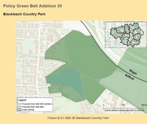
Meanwhile, five Salford sites have been added to the Green Belt - West Salford Greenway (184.5hectares) for which Salford City Council fought off Peel Holdings recently; part of the Logistics North Country Park (15.3ha), land West of Burgess Farm (25.2ha), land South East of Slack Brook (4.1ha) and Blackleach Country Park (34.1ha).
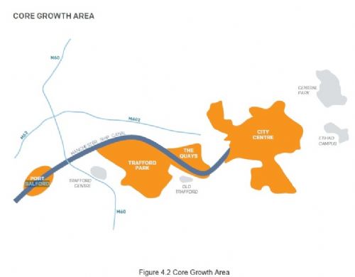
Away from the expected arguments over the Green Belt, land at Salford Quays has been identified for 192,000 sqm of office floorspace and around 12,500 new dwellings during the timespan of the Framework, 2020 to 2037, while over the whole city the split of properties will be 80% apartments and 20% houses.
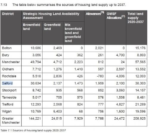
Salford is expected to supply land for 38,303 properties over the next 17 years, with 30,364 on brownfield land (see table)
"Manchester and Salford will continue to be an appropriate location for the highest levels of new housing due to their central location, good public transport connections, proximity to the main concentrations of employment and leisure opportunities, and ability to deliver very high density developments" the document states.
To, kind of, mitigate the looming concrete jungle, a new City Forest Park, "a vast urban forest close to the City Centre", will be established.
The Greater Manchester Spatial Framework will be discussed by Greater Manchester Leaders this Friday 30th October, before councillors in all ten boroughs will vote to endorse it during November.
If approved by all ten districts, the Framework will go out for an eight-week public consultation, beginning Tuesday 1st December.
"The Greater Manchester Spatial Framework is the cornerstone of our plans for the future" says Greater Manchester Mayor, Andy Burnham "This is a plan by and for all ten boroughs, setting out how we can direct the sustainable growth that will benefit our communities and help Greater Manchester recover from the effects of this crisis.
"Since the first draft went out to consultation in 2016 you have responded in your thousands, and we have listened" he adds "This final draft has seen plans for green belt sites cut by 60 per cent, with a focus on bringing forward brownfield development wherever possible. Our plans will protect our most important natural areas, deliver a sustainable travel network, and guard our boroughs from the risk of unplanned development.
"While we continue to confront the coronavirus pandemic, we also have a duty to look ahead and make sure our city-region builds back better for our people and places" he explains "The Spatial Framework is about making sure our city-region leads the way in providing good jobs, good housing, and tackling the climate crisis. The plan we're publishing today will be the blueprint for how Greater Manchester faces the future together."
And Salford City Mayor, Paul Dennett, GMCA Lead for Housing, Homelessness and Infrastructure, adds "This plan represents a shared vision for Greater Manchester, and it's by working together across the city-region that we've been able to direct development to the most sustainable brownfield areas – primarily the cities and town centres – and minimise development on Green Belt as much as possible."
Before the Framework goes out to consultation residents can read it by clicking here
For a full background see previous Salford Star articles on the Spatial Framework...
Greater Manchester Spatial Framework Sees Green Belt Destruction (2019) - click here
Irlam and Cadishead Community and MP Slam Green Belt destruction (2017) - click here
Salford Green Belt Attack (2016) - click here


.jpg)
.jpg)


.jpg)


.jpg)
.jpg)
(3).jpeg)
.png)
(1).JPG)
