Salford has 49 new coronavirus cases, down from the previous day's 64, bringing the cumulative total to 13,914, as the overall fall in infections levels off. The seven day average of cases has increased slightly from 338 to 346, as has the seven day rate per 100,000 population which rose from 130.6 to 133.7.
Elsewhere in Greater Manchester, all boroughs, except Rochdale and Tameside, have seen slight rises in infections.
Cases in Manchester during the latest seven day data period were 950 (up from 941), with a rate of 171.8 (up from 170.2), followed by Bolton with 477 (up from 473), with a rate of 165.9 (up from 164.5), and Oldham 383 (up from 367), with a rate of 161.5 (up from 154.8).
Wigan has 633 (up from 615), with a rate of 192.6 (up from 187.1), Tameside 250 (down from 267), with a rate of 110.4 (down from 117.9), Rochdale 450 (down from 479), with a rate of 202.3 (down from 215.4), Stockport 356 (up from 334), with a rate of 121.3 (up from 113.8), Bury 444 (up from 432), with a rate of 232.5 (up from 226.2), and Trafford 203 (up from 202), with a rate of 85.5 (up from 85.1).
There have been two new virus-related deaths at Salford Royal Hospital.
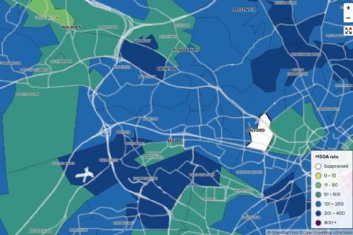
The latest interactive map of COVID-19 cases and seven day rates in Middle Super Output Areas for the week ending 6th December shows most of Salford now coloured pale blue, with rates between 101 and 200 per 100,000 people.
The exceptions were dark blue areas, with rates between 201 and 400, and green areas with rates of 51 to 100, with light green areas 11 to 50...
The highest rates were...
Broughton Park – rolling rate 369.4
Patricroft – 294.5
Peel Green - 261
Swinton West – 251.3
Kersal Dale – 222.6
Lowest rates were...
Walkden North West – rolling rate 48.7
Salford Central and University – 52.9
Walkden North East – 59.2
Ellenbrook and Boothstown – 57.9
Little Hulton North – 71.7
Walkden South – 73.8
Barton upon Irwell -76.1
Higher Irlam – 80.5
Clifton – 84.3
Swinton New Town – 98.4
Pendleton had fewer than three cases and is coloured white on the map with no further details...
To view the interactive map - click here and enter a postcode




.jpg)


.jpg)
.jpg)
(3).jpeg)
.png)
(1).JPG)
